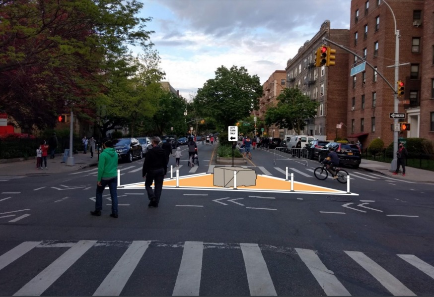
Rendering of proposed 34th Avenue street redesign that includes an open street barricade and diverters (DOT)
Oct. 25, 2021 By Max Parrott
The Department of Transportation unveiled its plan for 34th Avenue in Jackson Heights last week and residents learned that the stretch will not be converted into a car-free linear park.
Instead, the agency presented a plan to Community Board 3 on Oct. 21 to turn the 1.3-mile corridor that runs from 69th Street to Junction Boulevard into a series of pedestrian plazas and traffic-restricted zones.
The 34th Avenue stretch has long been regarded as the gold standard of Open Streets, a program that began in 2020 to provide extra outdoor space for residents during COVID-19.
The DOT plans to install four plaza blocks and a series of traffic demarcations along 34th Avenue aimed at slowing down cars and preventing them from traveling more than one block at a time.(click for presentation)
The plaza blocks will be located from 69th to 70th streets by PS 398, from 73rd to 74th streets by IS 230, from 77th to 78th streets by Travers Park and 93rd to 94th streets by PS 149.
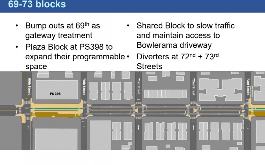
DOT plans to install a plaza block by P.S. 398 (DOT)
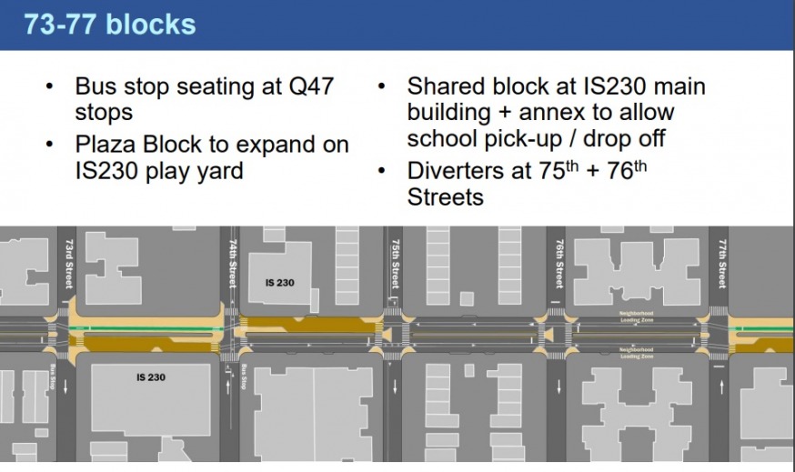
DOT plans to install a plaza block by IS 230, as well as a shared street block next to it (DOT)
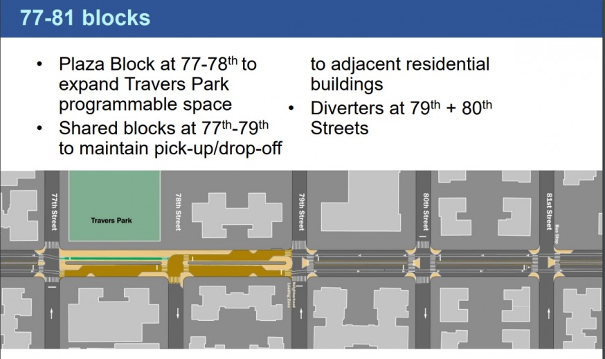
DOT plans to install a plaza block by Travers Park, and a shared street block between 78th and 79th (DOT)
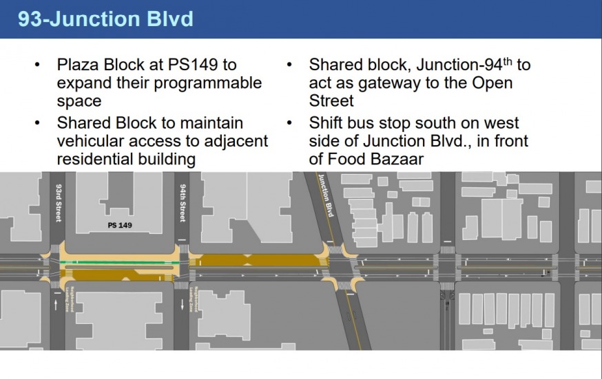
DOT plans to install a plaza block by P.S. 149 and a shared street block between 94th Street and Junction (DOT)
These plazas will take up the street on the northern side of the median, where traffic will be fully blocked off by granite blocks, and bike lanes will be designated with paint.
On the southern side of these plaza blocks, the DOT will create a “shared street” configuration, with traffic markings and curb extensions that will allow vehicles to enter the block for parking, pick-up and drop-off, but restrict their speed.
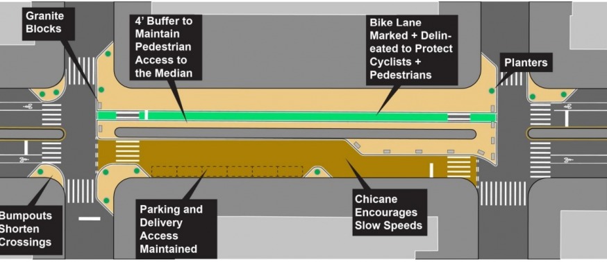
Plaza Block (DOT)
The overarching 34th Avenue plan is aimed at enhancing the current open street setup, which simply consists of a series of moveable barricades and planters at the entry point to each block.
In addition to the plazas, the plan involves several “shared street” blocks and a system of “diverter” traffic demarcations that will prevent through traffic and make the corridor less reliant on moveable barriers.
DOT urban planner Jessica Cronstein explained that the agency worked with residents and local institutions like schools to come up with a plan.
The agency will install what it calls traffic “diverters” along every intersection of the open street.
The diverters consist of a triangular street demarcation and a granite block that will force cars to turn onto the adjacent north/south streets at the end of each block. The design will still rely on barriers on one side of the street that can be moved so that cars parking or doing deliveries will be able to slowly move through the block.
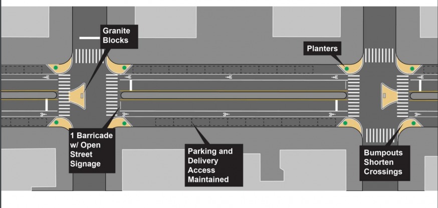
Street configuration with diverters (DOT)
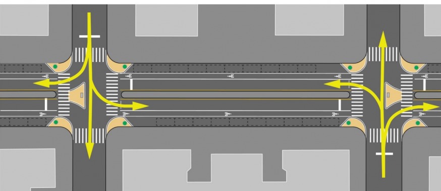
Diverters (DOT)
“This would be 24 hours a day. It would be all year round. We would be changing the geometry of the street so that through movements along the corridor for vehicles are no longer possible,” said Cronstein.
The DOT says that the design stems from outreach it conducted, with more than 2,000 people surveyed. The DOT reported that 93 percent of the survey respondents were Jackson Heights residents, and nearly a third of the participants listed 34th avenue as the closest intersection to their home.
Cronstein pointed out that it’s an incredibly well-used corridor by pedestrians.
Nearly 50 people signed up to give feedback at Community Board 3 Thursday, with some completely opposed to the open streets concept. Others raised concerns about the implementation of the plan and how it would affect accessibility and traffic on neighboring streets—while others asked questions about whether the proposed traffic restrictions go far enough.
The DOT said that it would take the feedback into consideration as it finalizes the design. Its next step is to coordinate with the MTA, FDNY, NYPD and Sanitation Department for approval, and begin to make the changes in the spring.
Several Open Streets opponents accused the DOT of not listening to the public—and not being open to scrapping the program. Some criticized the DOT’s survey methodology, arguing that it did not accurately reflect the residents who opposed the permanent open streets plan.
“It was not a forgone conclusion,” Cronstein said, who maintained that the extension of the open streets plan reflects the majority of the residents that the agency had heard from.
Some residents had questions about how the diverters would work. Several shared concerns that creating a design where bikes and pedestrians intermingle on the same block would lead to crashes.
The DOT responded that accidents resulting in injuries have gone down under the open street program on 34th Avenue. The number of pedestrian injuries for the three-year average prior to the open street was 11. Now it’s down to seven, Cronstein said.
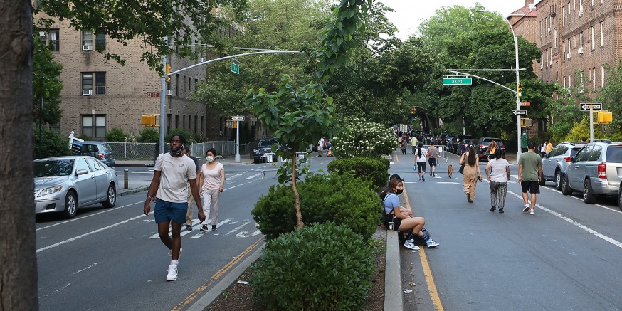
Dozens of people walking and jogging on 34th Avenue this spring (Photo: Christina Santucci/QueensPost).
A 34th Avenue resident, James Taylor, asked about the DOT’s communication with Access-A-Ride drivers, who, he said, sometimes refused to move the barricades.
The DOT responded that the agency had an accessibility coordinator, who has been working extensively to field complaints from Access-A-Ride passengers on a case-by-case basis.
One resident, who said her children attend school in Sunnyside, asked what impact the changes would have on bus routes. She said that the bus her kids take that goes along 35th Avenue has been arriving late to school.
Cronstein said that the DOT is in the process of reaching out to the Office of Pupil Transportation about the new design’s effects on bus routes and added that the agency will follow up about any problems it’s causing under its current configuration.
3 Comments

We’re the f$$k if every one pose to park there car now. This will make parking congestion even worse now
34 avenue between 82 and 83 streets just had installed “no standing anytime” signs on both north and south side of street. Anyone knows why?
The slow maneuver towards a car-less city is to make more and more people reliant on government transportation so that it’s difficult for people to escape.